
EMME-CARE develops innovative unmanned aerial system to map air pollution over Nicosia
By Dr. Christos Keleshis & Dr. Florin Unga
Air Quality models can be used in forecasting mode to help us to better predict (and adapt to) major pollution events due to near-by or long-range transported sources such as desert dust. They can also serve the design of efficient local action plans, for instance, by testing the benefits of different emission scenarios and/or abatement measures. The validity and accuracy of these Air Quality models critically depends on the availability of atmospheric observations, not only at ground level, but also in the atmospheric column to account for the vertical dispersion of air pollution. If ground-based atmospheric observations are quite straightforward to obtain, vertical information is much more difficult to acquire and remote sensing technologies can only partially bridge our current gap in vertical observations of air pollutants.
From this perspective, Unmanned Aerial Systems (UAS) are likely to become a strategic tool for the atmospheric sciences community. Whether they are employed for atmospheric profiling or specifically, for closer to the ground monitoring (e.g. flux measurements, plume characterization, etc.), UAS have already demonstrated their potential to serve scientific research in an efficient and cost-effective way.
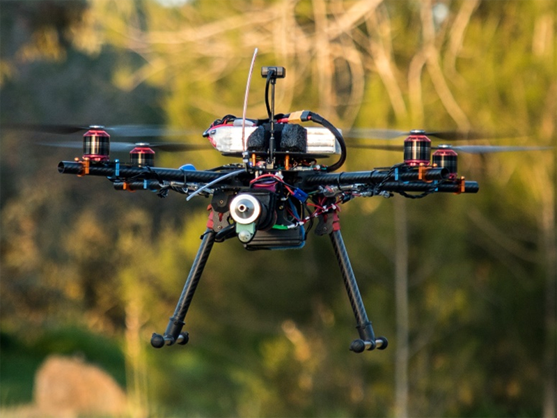
A team of young scientists and technical experts of the Cyprus Institute (CyI) has developed a very promising UAS, based on an automated lightweight quadcopter built and qualified within several EMME-CARE research facilities (Unmanned Systems Research Laboratory, Instrumentation Laboratory, Cyprus Atmospheric Observatory). This UAS has been optimized for the acquisition of dense (every 20min) and continuous (for several hours) vertical profiles of particle size distributions and their mass concentration (PM2.5) up to the altitude of 1.5 km. Its small size and light weight, along with its large take-off weight-to-payload ratio, makes it an easy, cost-effective, and low-risk system to operate, which is ideal for narrow airspaces in urban environments. These specifications make this new UAS ideal to document the Planetary Boundary Layer (PBL) development at a high temporal resolution and characterize the vertical dispersion/dilution of ground-based emitted urban air pollutants.

UAS-OPC pre-flight checks during night time.
The performance of this UAS was successfully tested during winter 2019-2020 over Nicosia with intensive (up to 15) vertical profiles of PM2.5 up to an altitude of 1,500 meters above ground level (AGL) in order to characterize particulate pollution within and above the PBL. The campaign lasted for 8 hours and started at 05:00 local time in order to capture the traffic-induced morning pollution peak and its vertical dilution along with the development of the PBL. To the best of our knowledge this is first time that such intense in-situ vertical profiling of PM is performed using Unmanned Aerial System. As depicted in Figure 1, the vertical dispersion of fine particulate pollution can be depicted with concentrations close to 15µg/m3 close to the ground and close-to-zero concentrations at only few hundred meters above ground. Concentrations close to the ground increase during the morning traffic peak and get diluted later with the development of the PBL.

Figure 1: PM2.5 mass concentration (µm/m3) vertical distribution over Nicosia. Measurements taken on 28th February 2020 between 05:00 and 12:00, local time.
It is envisioned that the versatility of this new UAS system will offer to a large range of end-users with an easy-to-use and cost-effective solution to perform dense profiling of various air pollutants; hence, further popularizing and expanding the utilization of UAS in the field of atmospheric sciences while offering valuable data EMME-CARE to better constrain the Cyprus Air Quality model currently under construction at the Cyprus Institute.

Confirming OPC proper operation before take-off 
The UAS-OPC lightweight quadcopter